UAS Services
UAS/CAUS Operations and Security Division
"Eye in the Sky, Shield on the Ground"
Intelligence, Surveillance, and Reconnaissance (ISR) operations
At ND3, we empower law enforcement with advanced drone solutions built for ISR operations. Outfitted with ultra‑high resolution optics, thermal imaging, and precision sensors, ND3 drones capture actionable intelligence from above—around the clock. Whether your agency is monitoring mass gatherings, tracking persons of interest, mapping crime scenes, or aiding search missions, our platforms deliver unmatched situational awareness with minimal operator risk.

By replacing or supplementing manned aircraft with ND3’s ISR drone systems, agencies benefit from enhanced agility, cost efficiencies, and faster response capabilities. With ND3’s ISR offerings, law enforcement can elevate investigative power, sharpen decision-making, and bolster public safety during critical incidents.
Enhancing Search and Rescue with Aerial Precision
Drones can be incredibly helpful in search and rescue (SAR) operations. Equipped with cameras, they can quickly survey large areas to locate missing persons, and thermal imaging capabilities allow them to detect body heat, even in nighttime or obscured searches. Drones can also access areas that are difficult or impossible for rescue teams to reach, such as disaster zones or rugged terrain. By transmitting live footage to SAR teams, drones enhance situational awareness and support more efficient operations. This technology can lead to faster response times, improved safety for rescue teams, and increased chances of successfully locating missing individuals, making drones a valuable asset in various SAR scenarios.
Transforming Crime and Crash Scene Investigations
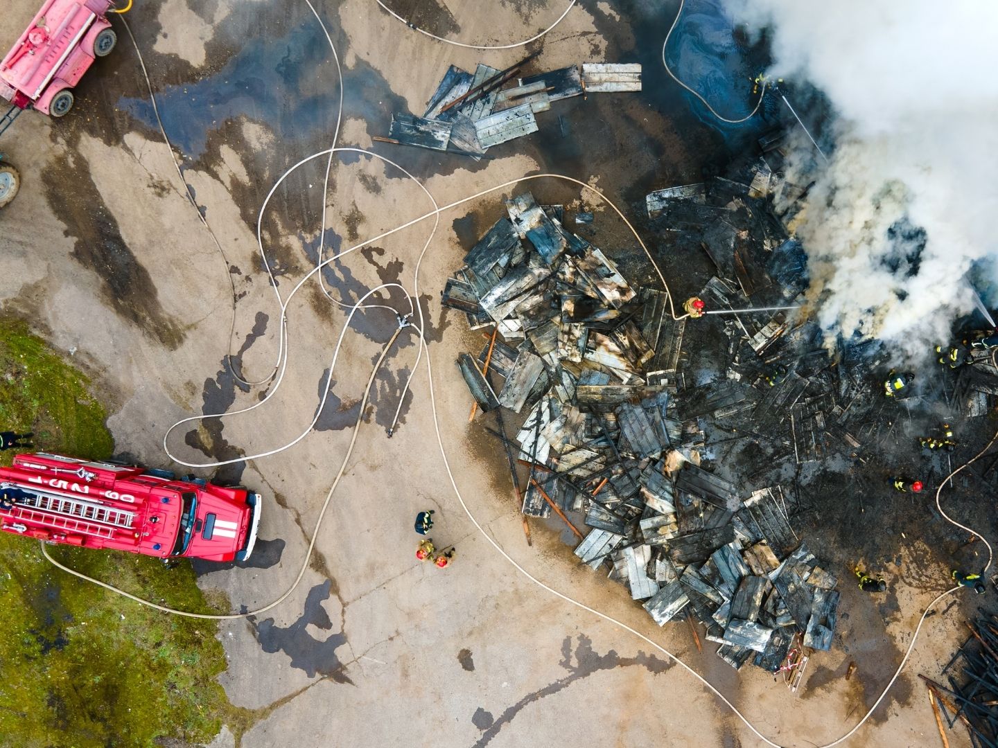
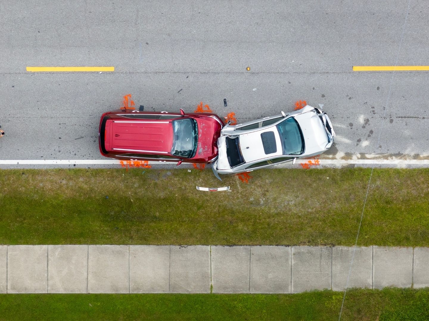
Drones are increasingly being used to document crash and crime scenes, offering several benefits. They capture high-resolution aerial footage and photos, providing a comprehensive view of the scene that helps investigators document evidence and damage, create detailed 3D models, and analyze scene layout and trajectories. This technology can also enhance courtroom presentations. By utilizing drones, investigations can be conducted more efficiently, reducing the time required to gather evidence and minimizing road closures. Additionally, drones improve safety for investigators by allowing them to survey scenes from a distance, and provide valuable insights for reconstruction and analysis, ultimately leading to better-informed decision-making.
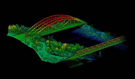
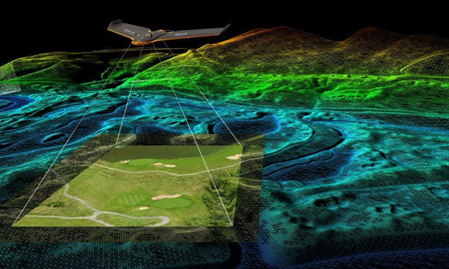
Mapping/ Photogrammetry
At ND3, we have experienced pilots and advanced software ready to support your aerial mapping and photogrammetry needs. Whether you’re in Federal, State, or Local Law Enforcement, part of the Department of Defense (including Armed Services), or operating in the private or public sector—from commercial to residential applications—we’re here to help. The possibilities are virtually endless, and our drones meet or exceed industry standards for safety, precision, and quality. While not a complete list, read more for just a few ways we can assist.
Aerial Mapping in Support of Your Construction Needs
Aerial mapping is a powerful tool that enhances construction planning, monitoring, and execution. By using high-resolution drone or satellite imagery, construction teams can obtain accurate topographical data, assess site conditions, and track project progress in real time. This technology improves efficiency by identifying potential obstacles, optimizing site layouts, and ensuring precise earthwork calculations. Aerial mapping also increases safety by reducing the need for on-site surveying in hazardous areas. Whether for land development, infrastructure projects, or large-scale construction, aerial mapping provides a cost-effective and reliable solution to support informed decision-making and successful project completion.
Survey quality products using ground control points(GCPs) and check points. (Can also bring in a 3rd Party licensed Surveyor)
GIS data deliverables compatible with industry standard formats for us in your heavy machinery
(TOPCON and Trimble Compatible)
Aerial Mapping in Support of Disaster Relief
Aerial mapping plays a crucial role in disaster relief by providing real-time, high-resolution imagery that helps emergency responders assess damage, identify hazardous areas, and coordinate relief efforts efficiently. Using drones, satellites, and aircraft equipped with advanced sensors, responders can quickly survey affected regions, even in areas that are inaccessible due to debris or dangerous conditions. This technology enables faster decision-making, helping to locate survivors, direct aid where it's needed most, and support long-term recovery efforts.
By offering accurate and up-to-date geographical data, aerial mapping enhances disaster response, minimizes risks, and ultimately saves lives.
•We have long range birds that are able to immediately map an area after a disaster.
•We can share real time data* with first responders/Crisis management Centers.
•Can support responders in bringing first aid and basic life saving supplies to stranded civilians.
Contact Us
Learn more about our capabilities, past work, and how we can help your organization achieve its mission.